


Geolocation: You Are Here
While Apple’s geolocation software recently “lost” two users in the middle of the Australian desert and China announced that it will begin a satellite counteroffensive, proposing an alternative to the American GPS hegemony by 2020, our everyday relationship to cartography is rapidly deteriorating and the connection between territory and its mapping is increasingly eroding. Supplanted by Google’s satellite zoom, the map is also being overtaken by the same software’s “street view,” which spares users the trouble of traveling on the ground. It is as though Art & Language’s conceptual exercises, notably those seeking to isolate American States on a blank page (Map not to indicate…, 1967) had anticipated the current territorial dematerialization.
Since the end of the 1990s, David Renaud, a forty-year old French artist, has developed a sculptural practice of cartography that generates a concrete experience for viewers, who are more accustomed to planar observations in this field. In fact, in order to introduce Renaud’s approach one could draw up a long genealogy of cartographer, geographer and also topographer artists, who tend, for the most part, to limit themselves to the map’s original characteristic: its two-dimensionality. Though this artist does not escape this atavism, for he himself retouches maps and engages in graphic and pictorial games, the way in which he works with our relationship to scale and volumetry alters viewers’ readings by involving them in an attentive, even prudent, surveying; in an in vitro exploration of the world of geography and its cartographic attire.
Îles Kerguelen, 2002
Several thousand nautical miles from any coast, these islands are “pebbles” lost in the middle of the ocean. If you search for them on Google, you will need to zoom out to locate them more precisely. In other words, they are but a crumb in the blue azure that characterizes expanses of water, according to cartographic codes. To identify the lands isolated in the middle of the ocean, you must constantly adjust the scale to evaluate your position on the world map and situate yourself mentally. In 2002, David Renaud enhanced this reflex with complex ambiguity by placing the Southern Kerguelen Islands in the middle of the Crédac exhibition room. The topographic 1:25000-scale reproduction of these islands dedicated to scientific residencies was displayed on the floor of the slightly slanted space, thus allowing viewers to physically experience the sensation of remoteness. Renaud reshapes this conquest of the far — a notion that is more readily associated with landscape — by physically inviting the viewer to fully assess a model that has been turned into a place. The zoom, the overview, the bird’s eye view, the passage from the macro to the general and the reverse, are no longer simply conceptual but are now part of the register of sculpture and that of the articulated body. All these means are brought together to confront this abstract scale par excellence, this standard measure of the National Geographic Society’s hiking and tourism maps. Just as one measures a distance with large steps, we — who are more accustomed to handle paper maps — will attempt to use David Renaud’s work to estimate a 1:25000 scale within its appropriate measure. At the Frac Lorraine, the same-scale mural representations of the Îles Antipodes, Îles Snares, Îles Campbell, Îles Bounty (2006) shown on the four exhibition walls (the surface of which varied between 32 m2 to 55 m2) incited viewers to geolocate themselves like a military strategist by using the display surfaces as positioning screens vis-à-vis these islands whose names evoke fiction and adventure. Once again, the entire body had to physically adjust and move in order to travel across this territory, which was made to fit perfectly within the limits of the gallery space. In reversing the reflexes currently being conditioned by Google, Renaud casts this geography into the real and makes it conditional to the site where it is shown as well as to its scale of reference (for national cartography).1 In sitting side by side without being fused, these two realities enhance the physicality of the experience. The map’s orientation function is diverted. You are here without really knowing where here is; a paradoxical effect of the white cube, the apparent neutrality of which Renaud heightens in order to better analyze the cartographic aporia.2 It is at the core of this tension zone that the artist deconstructs geography with its own instruments.
Everest II, ALT. 8848 m, 2008
With the passage to sculpture, David Renaud highlights his deconstructive exploration of what underpins maps. In Everest II, the mythical summit is placed on a cylindrical openwork wooden frame. This is a modest and technical pedestal without charm, an orthonormal framework that in a way recalls the rigorous grid governing maps. The zone of disagreement between the map and its geographic representation is highlighted through this device whereby a mountainous shell supports a hollow mountain. This empty shell, which derives its overbearing stature from its simple attire, no longer conforms to the strict chromatic and stylistic nomenclature of geographic maps. The Everest is made of wood and painted uniform grey or white, depending on the versions. It is an accumulation of strata translating the many contours with unyielding regularity. David Renaud places the imperious relief, its area and size in a tenuous position, by exhibiting its gaping and gutted entrails. The model respects the strict scale references of 1:2000 for the vertical versus 1:3333 for the horizontal representation. This always precisely emphasizes the obvious unbalance of the grid layout that serves as the base for the geographical entropy, which has led to the complex form of the summit. The mythical mountain has been transformed into a trophy, gutted and turned into a statue like the head of a game animal. Everest II is a victory to be collected, an exploit that one can walk around, as one would with an in-the-round Daphne sculpture to examine its rough edges and probe the depth of its relief. The chromatic saturation adds to this representation, creating the optical illusion of a high-precision laser cut, although Renaud makes no bones about the painstaking craftwork that was required to produce the work. The relationship to circularity implicit in the work of Everest II refers to the ancestral estimation mechanics of geolocation based on world maps and terrestrial globes. In this case orientation proceeded from a subject who revolved the world in front of him or herself. Henceforth, it is the subject that revolves around his or her object to position him or herself; an inversion of hierarchies that David Renaud’s work addresses and seizes upon. In photography, one usually had to place a person in the image to give the scale of a monumental place and link it to the viewer’s reality. Here it is the viewer’s body that carries out this verification, thus territorializing the exhibition space and endowing it with a temporal dimension — far from cartographic speculations. In allowing one to experience the abstract theory of the 1:2000 scale via the 1:1 scale of the body, Renaud’s geography is less about indicating than generalizing, more about loss than reassurance. Half in and half out: armchair explorers can leave their comfort behind, because to make us experience cartography in the Google era David Renaud is bound to shake up our convictions.
Fuji-San II, 2003
The revered Japanese mountain, this absolute icon has undergone a metamorphosis after passing through David Renaud’s hands. Yet, everything is there: the form and contours. The scale model reproduction almost fully respects the genre’s didactic and educational mission. No wonder that the delicate red wall-to-wall carpet construction was exhibited in the children’s gallery of the Centre George Pompidou. Clad in red, this sacred mountain, this land of legend and symbol of Japanese identity is once again represented. The red hue conflicts with the realism of the volume and the clarity of the rendering. This topples nomenclatures and the retinal expedition ends up generalizing Mount Fuji as being just another mountain, just another circumscribed observation object. Stripped of its geographic claims and codes, the symbol has become a pleasant miniature mountain. The arbitrariness of the cross-section certainly contributes to this effect and leads one to fictionalize the real mountain. A sample taken from another world, this is what Fuji-San resembles: no wonder that David Renaud, after having explored geography in depth, has now taken a liking to science fiction. When he created Basse Mana S.E., Guyane Française, 2005, the red carpet fabric amassed on a circular surface made the reliefs look like a Martian landscape; even though it continued to be rigorously guided by reference data, the aesthetic shifted towards the fantastic.
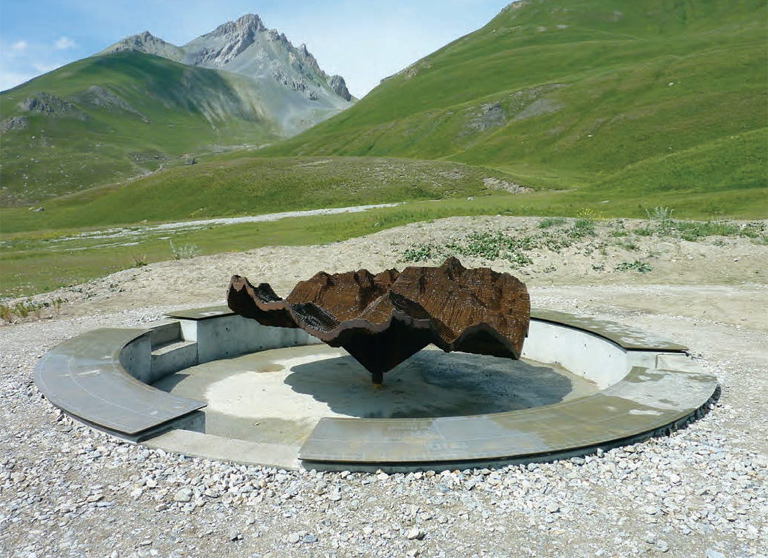
Col de Larche, 2011
Back on earth, things do not get any easier as the experience is transposed to a site: a landscape in this instance. The map is implicitly linked to the landscape: there are two representations — one mathematical, and the other subjective — which have become superimposed in common sense. For David Renaud this does not apply. In the absence of the white cube as a standard place from which to overturn cartographic codes, it is the reality of the landscape that will fuel an even more critical deconstruction. At the Col de Larche (Madalena Pass), on the Franco-Italian border, David Renaud developed a viewpoint indicator that presents hikers with a situation in which they cannot make the landscape and the artist’s vision correspond to one another. Lodged upon a circular podium, there is a steel representation of the area that is made using a concentric strata system similar to the one in Everest II. The sculpture reveals both its underpinnings and its relief, giving a totally artificial impression of the surroundings, their constructed nature drawing from both geography and the landscape genre.
A slab containing all the information indicates the peaks, altitudes, towns and localities of the nearby region. It is impossible to juxtapose David Renaud’s work with this information and the surrounding landscape at one go. If one wants to orient oneself in this landscape based on these indications, the sculpture is no longer within one’s field of vision. On the contrary, if one contemplates it, it is the site that is excluded. Technically site-specific, the work completely evacuates this condition to create its own space in a complex interplay of reversals. To find one’s way by forcing the sculpture to indicate anything whatsoever, one has to engage in some truly confusing contortions. This experience eloquently sums up the incompatibility of the relationship to the scale, between the real and its portrayal. Once again, the artist’s analytical representation claims its own space, its own temporality, which are incompatible with those of the landscape it is modelled on. With his cartography and topographic tools, David Renaud geolocates intermediary and unlisted zones. Using the same tools that help us to navigate the real world, these sculptures and their emplacement carve out what Marc Augé calls non-places, these symbols of supermodernity.3 But rather than placing them in the international zones of airports, highways or standardized shopping centres as the anthropologist does, David Renaud builds his non-places from mythical sites, territories, and precise geographic data. For instance, when he undertook his Atlas des 119 jours autour du monde (2006) based on the route taken by the sailor Marc Thiercelin in the solitary Vendée Globe 2004-2005 race, the artist listed the boat’s exact daily positions with an obsessive rigour. This cross against a blue background is a non-place — a rough patch in cartographic reality — that widens the space of our mental and physical experience by burrowing a temporal fault line in the rationality of the race position relations. The 119 plates, rendered in a nearly uniform blue, keep us up to date. Surely, you are here, that is what David Renaud lets us know.
Translated by Bernard Schütze
Bénédicte Ramade is an art critic, specializing in contemporary art with a concern for nature and ecology. Since 1999, she has been on the editorial staff of the magazine L’oeil and has also written for many magazines, including Parachute and Zérodeux. As an independent curator, she looked at the artificializing of nature in Acclimatation (Villa Arson, Nice, 2008-2009) and has shown ecological interpretations of recycling in REHAB, l’art de refaire (Espace EDF, Paris 2010-2011). A lecturer at Université Paris 1 – La Sorbonne, she recently completed her doctorate, which focused on Infortunes de l’Art écologique américain. At present, she is preparing her move to Quebec.
-
In his Being Circumstance: Notes Towards a Confidential Art (1985), Robert Irwin classifies the possible nomenclature conditions for onsite or public art: Site dominant, Site adjusted, Site Specific et Site conditioned ou determined : « Here sculptural response draws all of its cues (reasons for being) from its surroundings. This requires the process to begin with an intimate, hands-on reading of the site. This means sitting, watching, and walking through the site, the surrounding areas (where you will enter from and exit to), the city at large or the countryside », in Being and Circumstance, Larkspur Landing, Lapis Press, 1985, p.9-29.
-
Brian O’Doherty, Inside the White Cube: The Ideology of the Gallery Space, Expanded Edition, San Francisco, University of California Press, 2000, p.15 : “Unshadowed, white, clean, artificial, the space is devoted to the technology of esthetics. Works of art are mounted, hung, scattered for study. Their ungrubby surfaces are untouched by time and its vicissitudes. Art exists in a kind of eternity of display, and though there is lots of ‘period’ (late modern), there is no time.”
-
Marc Augé, Non-Places: Introduction to an Anthropology of Supermodernity, trans. John Howe, London, Verso, 1995.